
Because there’s nothing more beautiful than the way the ocean refuses to stop kissing the shoreline, no matter how many times it’s sent away – Sarah Kay
I’m getting close to the end of my motorcycle quest for the best beach in coastal Queensland. Today I ride from Ellis Beach through the Daintree Rain forest, over the Bloomfield Track to the Lion’s Den Hotel. There are so many awesome sections of coast to ride in Australia. The ride from Ellis Beach to Port Douglas and the ride through the Daintree Rain Forest would be two of the most spectacular.
The coastal road winds along the edge of the Coral Sea on the other side are the high cliffs of rain forest, this creates a sense of awe. It has beautiful sea vistas and winding up hill climbs that will bring out the carefree child in all bikers. It culminates in a look out with the most spectacular views.
I’m on a motorcycle quest to find the best beach on the coast of Queensland. I have ridden from Coolangatta on the border of Queensland and New South Wales to Ellis Beach in tropical North Queensland. I intend to finish my quest in Cooktown tomorrow.
Seeking the Daintree
Today I will ride the Daintree Rain Forest and the Bloomfield Track to the famous Lion’s Den Hotel. If you found this page in a search and would like to know more about my motorcycle quest, click on the links below:
Townsville to Lucinda Beach Part 1 of my quest for the best beach in Queensland
Lucinda to Mission Beach Part 2 of my quest for the best beach in Queensland
Mission Beach to Ellis Beach Part 3 of my quest for the best beach in Queensland
(opens in a new tab)


Borderline Beach
On this motorcycle quest I have seen some amazing roads and beach areas. The foreshore drive is called the Great Barrier Reef Drive. The beach along the Highway foreshore is the Borderline Beach which extends around the point to Oaks Beach. Before you get to Oaks Beach you have to traverse the McAllister Range. The range is a biker’s dream road with tight corners, fast up jumps and twisty downward curves. It comes out again just inland of more coral crusted sand lined beaches. The road sweeps you along the tropical foreshore. You can pick any number of exit points and sit beside the spectacular coral sea.
I wanted to continue on my adventure and make my way to the Lion’s Den Hotel. It was going to be a long day and I had a variety of environments to traverse. Not the least of which was the very steep Bloomfield Track and the notorious Emmagen Creek. After riding through the beautiful coastal strip you come straight into Craiglie, which is a small suburb of Port Douglas. The beach joins onto the famous Four Mile Beach.
Port Douglas
As with so many other towns in this area, Port Douglas came to be as a result of the discovery of gold. It was established in 1871 after James Mulligan discovered payable gold at the Hodgkinson River. At one point there was an estimated 12,000 residents and 27 hotels in the town. Once the Mulligan Highway was developed it became a support town to all the communities along the highway as far as Herberton.
I have written about the Mulligan Highway in part one of my Cape York Adventure series. You can read about it at the following link: https://digitalswaggie.com.au/cape-york-adventure-the-ultimate-motorcycle-ride. The main road up to the Mulligan Highway, joins Mossman to Mount Malloy. This road winds up and over the great dividing range in a twisting climbing zig zag pattern.
Port Douglas declined once the Kuranda Railway from Cairns was built and access north became easier. However, in the 1990’s the infamous Christopher Skase built the five star Sheraton Mirage Resort, other entrepreneurs arrived and Port Douglas became a tourism mega for the rich and famous. In 1996 the USA president Bill and First Lady Hillary Clinton stayed in the town, cementing its position as an up market go to destination.
Lots going for it
The town has a lot going for it, from restaurants, to cafes and even up market cocktail bars. A number of dive vessels operate out of the port, and it’s in a great position to service some of the better outer reefs.
It is within driving distance of the world heritage Daintree Rain Forest and just down the road from the equally impressive Mossman Gorge. But I was here to check out one particular beach. Four Mile Beach has a reputation as being one of the best in Queensland, well that’s why I’m here.


It’s difficult sometimes to be at a beach at exactly the right time to get a good photo. I guess that’s what makes this journey of mine so interesting. I see beaches as they are everyday. Four Mile beach is spectacular and I have been here at different times where the water has been crystal clear. What differentiates a good beach from a great beach is how it makes you feel, when you walk along the sand or swim amongst the waves.
There’s no doubt that Four Mile Beach is one of those beaches that seems to relax you as you walk along it. I’m not sure if its the slow shallow entry, the palm and coconut trees or the secluded peaceful gardens before you access the beach. Or maybe it’s the pub, coffee shop across the road that offers respite from mundane life of cooking your own food?
Town Centre
Port Douglas is more than just Four Mile Beach, there’s a boat harbour, up market shops, a bewildering selection of pubs, cafes, restaurants and even a fisherman wharf type place with live music and locally brewed beer. There’s a sense of history and colonialism here with the old church and sugar cane wharf. A perfect place for a cup of coffee.


I took my boots off to cool down my feet while I waited for my billy to boil. Just as two well dressed middle aged women with pearls and gold dripping from their neck and wrists walked by and looked at me with a slight hint of annoyance or was that distain, who cares.
Soon it was time to leave, I still had a long way to travel for the day. Ordinarily, I would have stopped at Mossman, its an awesome little town and if you haven’t gone to Mossman Gorge it’s well worth a visit. But I had one more beach to explore before I crossed the Daintree River and headed into one of the oldest rain forests in the world.
Wonga Beach
Wonga Beach community was established in 1898, but in 1770 Captain Cook named the small island in northern part of the bay “Snapper Island” and the small coral cay “Low Isles”. The community is situated just south of the Daintree River and North of Mossman. It is a community in the process of development from a small holiday community like so many others up the coast to a up market seaside town.
The beach is spectacular and typical of your tropical beaches, with rain forest mountains in the back ground, palm, coconut and rain forest trees down to the beach. As I rode up the coast I joined back onto the shore line. On the right side of the road tucked quietly amongst a forest was the Wonga Beach turn off. There was a small park just at the turn off with a toilet block and kids play ground.
More than expected
I explored the town riding around the modern urban community. It was bigger than it looked from the road and more developed than I had expected when looking at it on the map. It took some time to find the beach area. For some reason I kept going down the wrong road, there was no esplanade like many of the the other communities. The beach and caravan park are tucked away in forested areas. It’s a place I could find myself camping at some time in the future.


Once I got back to the toilet block and kids play area, I could see a small track running along the beach area. I rode as far as I could down this track. The distance between the houses and the beach was about 120 metres and the bush area was undeveloped. I was able to ride through it without any concern from the residents. Unfortunately I couldn’t ride all the way to the beach access area. The bush got thicker and more isolated, so I turned back. The following web page provides more information about the facilities at Wonga Beach https://www.destinationdaintree.com/locations/wonga-beach
Looking south you can easily see the head lands that are Port Douglas, while looking north towards Snapper Island you can make out the mouth of the Daintree River and further north Cape Kimberley. I stayed here for sometime, but became anxious to continue on my journey. I had to continue my motorcycle quest to find the best beach in coastal Queensland. It wasn’t far to the Daintree Ferry and the start of my next section of this adventure.
Two world heritage areas
Once back on the road I rode past a service station and then a Barramundi farm and turned at the sign for the Daintree Ferry. The Daintree River came into view right in front of it the ferry office. The Daintree River is wider than you would expect. It is also crocodile infested waterway so there was no thought of swimming near by. For those adventure riders on smaller bikes the Daintree River is actually ridable further up and is the first hurdle to riding the Creb Track.
I paid my fee and waited for the ferry to return. In the next blog post I explore the Daintree Rain Forest and tackle the Bloomfield Track.
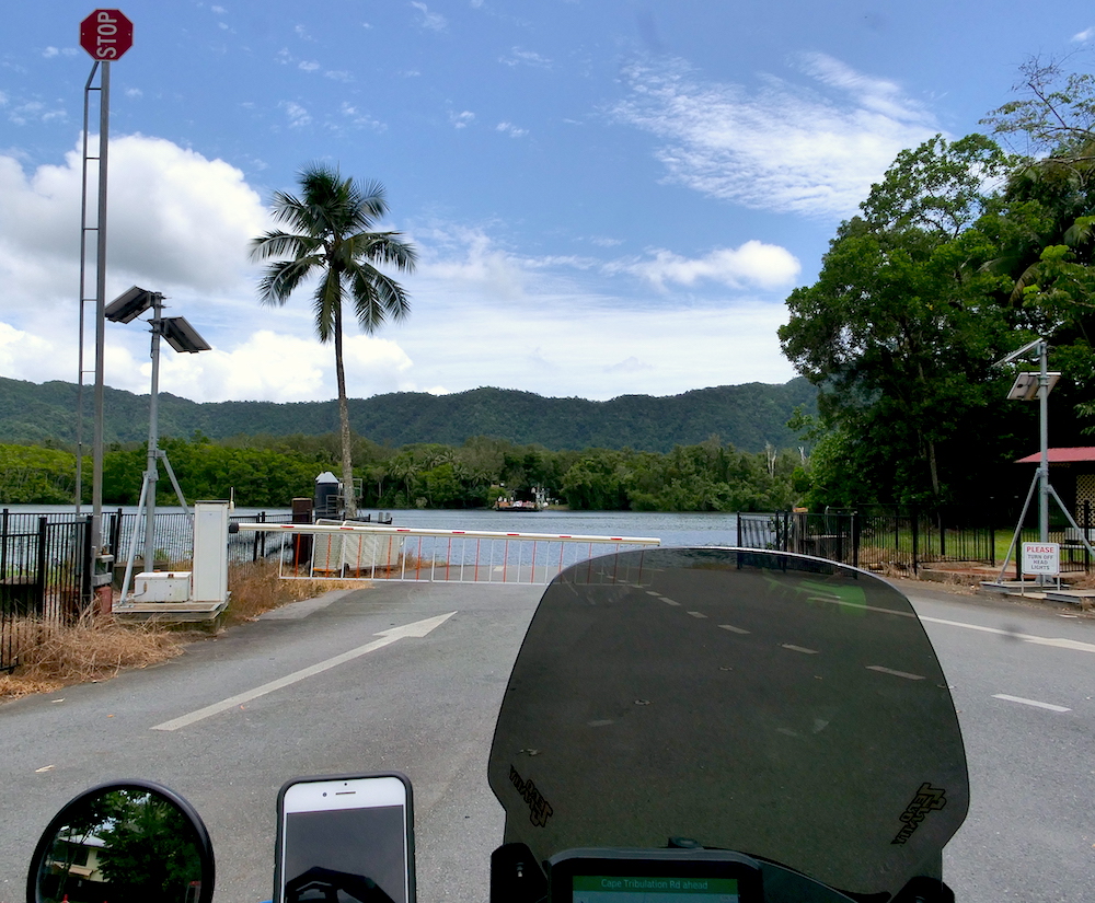
The Daintree Ferry is a crucial part of the story of the Daintree. It would be fairly easy to build a bridge. But public pressure has put future developments out of the question. The area north from here is unique in that it involves two world heritage areas side by side. They are the Great Barrier Reef and the Daintree Rain Forest. Daintree, life is slower, there is no electricity or other services, all facilities must be self sustaining with either solar or diesel generators.
If you want to continue reading about my adventures through the Daintree Rain Forest click on the following link:
Safe travels ….. 🙂

No responses yet